Sunday 2 June 2013

The Ethiopian Montane

Source google.com.pk
The Ethiopian Montane
The Ethiopian Montane Woodland ecoregion is biodiverse, poorly known and highly threatened. The rugged topography of this ecoregion rings the highlands of Ethiopia and Eritrea, extending to outlying massifs in Sudan. Formed by volcanic forces 75 million years ago, these highlands were covered with Eurasian tundra-like vegetation during the last Ice Ages. Today, remnant patches of natural vegetation consist mostly of podocarp and juniper forests, with some acacias found at lower elevations. While soils are rather infertile, this area is densely populated and most land has been converted to agriculture. Notable endemics found here include the yellow-throated serin and Prince Ruspoli's turaco. Many of the endemic species are threatened due to the loss of their habitat.


Ancient Precambrian basement rocks form the substrate of the montane forests in southwestern Ethiopia and Eritrea. The topography is generally rugged, and soils are rather infertile. The main Ethiopian and Eritrean dome began to rise 75 million years ago, eventually dividing into two halves, the northern and southern highlands. A turbulent volcanic period ended four to five million years ago, followed by climatic fluctuations in the Pliocene and Pleistocene. Glaciers formed on the peaks of the Ethiopian highlands while surrounding areas, including this ecoregion, were covered with vegetation similar to Eurasian tundra. Separated by the Great Rift Valley, the northern and southern highlands were colonized by new species from different directions. The jebels and escarpments along the Red Sea linked Eritrea and northern Ethiopia with the Palearctic region while southern Ethiopia had a rift-wall connection to the Horn of Africa. Both the western and eastern highlands were invaded by tropical species that could penetrate the Nile floodplains in the west or the Kenyan deserts in the south. Despite the climatic differences, the surrounding lowlands provided the most consistent source of new species, so that these highlands show both Afrotropical and Palearctic influences.


Northwestern Congolian Lowland

Source google.com.pk
 Northwestern Congolian Lowland 
The Northwest Congolian Lowland Forest ecoregion contains vast tracts of lowland forest, supporting core populations of the western lowland gorilla (Gorilla gorilla gorilla) and large numbers of forest elephant. Species richness and endemism are both high. Logging concessions and associated bushmeat hunting and agricultural expansion are the main threats to the habitats and species. There are some established protected areas, and the gazettement of new protected areas offers good potential for biodiversity conservation in the region.
There are an estimated 7,151 vascular plants found in Gabon, over 3,600 in the Central African Republic, 8,260 in Cameroon and 6,000 in Congo. A study in Gabon has shown that these forests are richer in plant species than those of West Africa. Reitsma found over 200 different species of plants in a 0.02 ha plot in Gabon, and Letouzey found 227 in a 0.01 ha plot in Cameroon. These are among the highest species/area counts for any vegetation the world.


Conservation initiatives over the last decade have resulted in a number of newly gazetted areas
. For example, the declaration of the Minkébé Forest Reserve (5,650 km2) marked a significant enhancement of the conservation area network in Gabon. In Congo, Odzala–Koukoua National Park (over 13,000 km2) has recently been extended. The Dzanga-Sangha forest in CAR is protected within the Dzanga-Ndoki National Park and the adjacent Dzanga-Sangha Faunal Reserve, totaling 4,347 km2, which is about eight percent of CAR's total closed forest estate. While the forest around Ngotto in CAR currently has no official protected area status, the Forêt de Ngotto (730 km2) is in the final stages of gazettement. In Cameroon, Dja, Boumba-Bek, Nki and Lac Lobéké protected areas cover an extensive area of lowland forest in the southern part of the country. One of the largest areas under protection is the Sangha Trinational protected area (10,650 km2), which combines the Nouabalé-Ndoki National Park (over 4,000 km2) in northern Republic of Congo, Dzanga-Sangha complex in the Central African Republic (CAR), and the Lobéké National Park in Cameroon.


Road and infrastructure developments increase interactions between humans and animals, to the usual detriment of the latter. One direct impact is the bushmeat trade, which primarily affects duikers (Cephalophus spp.) that can comprise up to 80 percent of the harvest in certain sites, and monkeys (Cercopithecus, Cercobcebus, Mandrillus, Colobus spp.). Larger antelopes, Tragelaphus spp., apes (Gorilla and Pan), buffalo and pigs (Potamochoerus, Hylochoerus) are also affected. Even top predators such as crowned eagle (Stephanoaetus coronatus), leopard (Panthera pardus) and golden cat (Felis aurata) are affected as their prey animals are hunted out.

The Northwest Congolian Lowland Forest ecoregion contains vast tracts of lowland forest, supporting core populations of the western lowland gorilla (Gorilla gorilla gorilla) and large numbers of forest elephant. Species richness and endemism are both high. Logging concessions and associated bushmeat hunting and agricultural expansion are the main threats to the habitats and species. There are some established protected areas, and the gazettement of new protected areas offers good potential for biodiversity conservation in the region.

The logging industries' role in this trade has been heavily debated. However, there is little doubt that they provide a market (the logging camps), a transport system (the logging trucks), and a means of access (the logging roads) that are invaluable to the bushmeat industry.

In addition to the bushmeat industry some species are also hunted for trophies, fetishes and the pet trade. Elephants are still extensively poached for their meat and ivory. The trade in African gray parrots (Psittacus erithacus) is well developed in some parts, especially in Cameroon where it threatens the survival of this species. Certain other species, such as crocodiles and lizards, face similar threats. Although professional safari hunting can be beneficial to conservation, this has rarely been the case in this ecoregion. Future threats to the forest include immigration of agricultural peoples into the logged forest areas.


KwaZulu-Cape Coastal Forest Mosaic

Source google.com.pk
KwaZulu-Cape Coastal Forest Mosaic
KwaZulu-Cape Coastal Forest Mosaic runs along the eastern coast of South Africa, a mix of forest interspersed by thornveld. This region represents the southernmost distribution for tropical faunas and floras in Africa, and contains highly endemic flora as well as some narrowly endemic animals. Although approximately nine percent of this ecoregion falls within conservation areas, the fragmented and isolated nature of these reserves makes them vulnerable to the high degree of anthropogenic pressure.
Distributed in a narrow band along the eastern South African coastline, this ecoregion represents the coastal tropical and subtropical forest of South Africa. It extends from Cape Saint Lucia (about 32° east), south along the eastern narrow coastal plain to Cape Saint Francis (26° south 33° east). Its inland boundary lies at the foothills of the Drakensberg Escarpment, from 450 meters (m) in elevation in the north, dropping to about 300 m in the south.


Forest species have a wide distribution in southern Africa and fall into two main floristic regions: the Tongaland-Pondoland forests of the Indian Ocean Coastal Region and the Afromontane forests of the Drakensberg escarpment, Natal, and eastern Cape midlands, the southern and southwestern Cape mountains, and coastal plateau. The vegetation of KwaZulu-Cape Forest Mosaic consists of the narrower (minimum 8 kilometers), southern part of Moll and White’s Tongaland–Pondoland regional mosaic. This regional mosaic is part of a greater Indian Ocean Coastal Belt extending down from the extreme southeastern corner of Somalia. The composition of the flora of the KwaZulu-Cape coastal forest mosaic, and the affinities of the species, is related to changes in the rainfall that tends to decline to towards the south. In addition, the generally colder temperatures of the southern portion limit distribution of subtropical species such as Natal wild banana (Strelitzia nicolai) that grows down near Port Elisabeth.


The Louisiade Archipelago Rain Forests

Source google.com.pk
The Louisiade Archipelago Rain Forests
The Louisiade Archipelago rain forests contain many endemic species of plants and animals, particularly birds, that help define it as a distinct unit. The main threats to the islands are logging, conversion of habitat into agricultural lands, and gold mining.

Location and General Description
The ecoregion includes a group island chain that lies off the southeastern tip of Papua New Guinea (PNG). The first islands moving eastward in the chain are close to the mainland and include Sideia and Basilaki islands. Further east are the major islands in the archipelago: Misima, Sudest (or Tagula), and Rossel. Sudest Island is the largest (800 square-kilometers (km2)). All of the major islands of the Louisiades are volcanic, although there are numerous smaller islands that are coral formations.

The climate of the Louisiade Archipelago is moist tropical, and the vegetation consists of rain forest, although some of the low-lying smaller islands receive less rainfall. Paijmans categorized most of the ecoregion as small crowned lowland hill forest. This type of forest is shorter (20-30 meters (m) in height) than that found in other areas in New Guinea because of either poor soil conditions or less rainfall. The former is probably the case, as Johns remarked on the very poor soils of Rossel and Misima. Tree genera in pure forest stands include Casuarina, Castanopsis, and Hopea. Paijames listed mixed forest genera for low rainfall areas as Pometia, Canarium, Anisoptera, Cryptocarya, Terminalia, Syzygium, Ficus, and Celtis.


Trobriand Islands Rain Forests

Source google.com.pk
Trobriand Islands Rain Forests
In October through May the high and low temperature stays very consistent. In June through September it is just a little bit colder. Since the Trobriand Islands are just nine degrees south of the equator it is very hot and there aren't really seasons. The Trobriand Islands are very wet and humid. The rainfall amount can be anywhere from eight to twelve inches per month.
 The biome I chose is the rainforest. It is unique because of all of the undiscovered creatures. There are over twelve types of rainforest trees and one conifer species, the hoop pine, which is a very tall pine tree. This rainforest is a very beautiful place and is a moist, warm ecoregion.

The region that the rainforest is in is Papua New Guinea. The ecoregion lies just off of the southeastern tip of Papua New Guinea. The largest portion of the ecoregion is made up of three different islands of the D'Entrecasteaux group: Good enough, Ferguson, and Normanby are the names of those three islands

The main plant species in the Trobriand Islands are rainforest trees. There are about a dozen different rainforest trees. This group of trees includes one conifer species, the Hoop Pine which towers over all of the other rainforest trees. Interestingly there are two endemic ant plant species (plants that have a symbiotic relationship with ants) symbiotic means that the plant depends on the ant and the ant depends on the plant.
Many of the herbivores in this region are insects. One of the most fascinating insects is a Phylliidae (walking leaf) These fascinating insects look like a leaf. They come in many different shapes and colors. They are very well adapted to their environment because they blend in very well with all of the trees and leaves. When they walk, they rock back and fourth imitating a leaf blowing in the wind.

Most of the predators are insectivores such as bats, marsupial (possum), and rodents. They prey on insects. Marsupials are very well adapted to there environment because they live in trees which the rainforest is plentiful in. For example the Striped Possum have a larger fourth finger to dig out insect larva that has burrowed into wood. They also have a wrist that if tapped on wood can locate insect larvae.

The people on the islands are mostly farmers that grow food to trade. They believe in spirits that cause things such as death, weather, and more. The main sport on the island is cricket. It is considered an honored sport and only the greatest can play. Magic is also a big part in their life. They believe in spells that can help their crops grow and keep someone alive. The elders and chief of the tribe have the greatest spells that can control many things.


One of the biggest threats in this rainforest is that people are taking down trees to make space for farms and are logging. This is killing many animals that depend on trees to survive which is causing extinction. The animals of the rainforest depend on trees to survive. Not only do the animals need trees but we do to. Trees produce oxygen instead of carbon dioxide. I think that for every tree taken down a new one needs to be planted. People are being careless and thinking that there are tons of trees and one won’t hurt. Pretty soon one will become hundreds if people keep thinking like that.


The ecoregion lies just off the southeastern tip of PNG in the southwest Pacific and includes Woodlark Island and two island groups: the D'Entrecasteaux and the Trobriand. The largest portion of the ecoregion and the nearest to the New Guinea mainland is made up of three principal islands of the D'Entrecasteaux group: Goodenough, Fergusson, and Normanby. Goodenough is the highest island in the ecoregion, reaching an altitude of 2,750 m, and Fergusson is the largest. Kaileuna and Kiriwina islands in the Trobriand group lie further out in the Pacific, and Woodlark Island is even further to the southwest. The ecoregion is warm and moist tropical, typical of most of New Guinea.

According to Whitmore (1984), Woodlark and the Trobriand Islands consist primarily of lowland rain forest on limestone substrates. Goodenough, Fergusson, and Normanby islands consist mainly of lowland rain forest on acid soil; however, Normanby has one area of ultrabasic soils. The major rain forest tree genera include Pometia, Octomeles, Alstonia, Campnosperma, Canarium (Burseraceae), Dracontomelon (Anacardiaceae), Pterocymbium (Sterculiaceae), Crytocarya (Lauraceae), Intsia, Ficus, and Terminalia (Mueller-Dombois and Fosberg 1998). The emergent the hoop pine (A. cunninghami) is present in the ecoregion on Fergusson (Mueller-Dombois and Fosberg 1998). The northwest portions of Goodenough and Fergusson islands are anthropogenic grasslands and agricultural lands.


Biodiversity Features
The ecoregion has many endemic species, but more certainly await discovery. The D'Entrecasteaux Islands in particular are thought to contain numerous endemic plant species (Johns 1993). The ultrabasic soils of Normanby have turned up exciting new finds, including two endemic ant plant species (Johns 1993). The forested mountains of Fergusson Island have never been surveyed biologically and are considered one of PNG's great biological unknowns (Swartzendruber 1993). Beehler (1993) emphasized this point, saying that the massif on Fergusson "promises to be a treasure trove to the first vertebrate biologists who climb its heights," and "one can only imagine what undescribed populations of vertebrates inhabit the wet montane forests above 1500 meters there." Goodenough Island contains an endemic bat (Dobsonia pannietensis) and an endemic forest wallaby, the black dorcopsis (Dorcopsis atrata). Woodlark Island is also considered to be very unusual botanically and contains an endemic cuscus (Phalanger lullulae).

There are thirty-eight mammal species in the Trobriand Islands Rain Forests [AA0125]. Most of these species are bats (twenty-four) in four families (Pteropodidae, Molossidae, Rhinolophidae, and Vespertilionidae), followed by rodent species (Muridae). Three species are listed as threatened (VU or higher) by IUCN (1996): black dorcopsis (Dorcopsis atrata), St. Aignan's trumpet-eared bat (Kerivoula agnella), and Tate's triok (Dactylopsila tatei). Four mammal species are limited to the ecoregion, and five more are near endemics (table 1).

Table 1. Endemic and Near-Endemic Mammal Species.

Family Species
Perorictidae Echymipera davidi*
Phalangeridae Phalanger lullulae*
Macropodidae Dorcopsis atrata*
Petauridae Dactylopsila tatei*
Pteropodidae Nyctimene major
Pteropodidae Pteropus pannietensis
Vespertilionidae Kerivoula agnella
Vespertilionidae Pipistrellus collinus
Muridae Chiruromys forbesi

An asterisk signifies that the species' range is limited to this ecoregion.

Most of the ecoregion, with the notable exception of Woodlark Island, is part of the D'Entrecasteaux and Trobriand Islands EBA (Stattersfield et al. 1998). Two bird species are endemic to the ecoregion (table 2). One of these birds, the curl-crested manucode, is found on all three major islands of the D'Entrecasteaux group and in the Trobriand Islands. The other, Goldie's bird-of-paradise, is listed as threatened (VU) by IUCN (2000) and is found only on Fergusson and Normanby.

Table 2. Endemic and Near-Endemic Bird Species.

Family Common Name Species
Paradisaeidae Curl-crested manucode Manucodia comrii*
Paradisaeidae Goldie's bird-of-paradise Paradisaea decora*

An asterisk signifies that the species' range is limited to this ecoregion.

Current Status
As mentioned earlier, the northwest portions of Goodenough and Fergusson islands are anthropogenic grasslands and agricultural lands. A scheme for a possible large-scale agricultural project on Normanby Island is mentioned by Stattersfield et al. (1998), but its status is unknown.

Northeastern Congolian lowland forests


Environmental archaeology is the study of early civilizations using techniques of biological markers that are intrinsic to the layer of human prehistory under investigation.  Our understanding of ancient man is enhanced by concurrent study of pollen cores,  plant and animal remains, fossil records;  even abiotic evidence such as sediment layering, changes in river meanders, ocean levels, salinity records and other inanimate data provide great context to life in earlier times.

The environmental data can not only provide insights as to the time horizons of early civilizations, but also gives direct insights to the lifestyles of those who came before us;  namely the dietary habits, proximity to water supplies, wood and clay used in primitive structures are all elucidated by collecting data on environmental features that pertain to the earlier time period.

Examples of archaeological conclusions that can be derived from certain environmental data include: intensity of resource exploitation; population levels and density; nature of society organization; division of labor.  Conversely the joint study of conventional archaeological excavation combined with environmental data collection yields important information that is useful to researchers who are concentrating on historical ecology, since the data can be reduced to yield insights as to distributional range of plants and animals relative to human populations; in addition, insights are provided regarding methods of harvesting plants and animals in the prehistoric landscape, that abet our understanding of the time change of species numbers and the influence of man on extinction processes.The highlighted green part is the Congo Lowland Forest. The Northeastern Congo lowland forest is located in Congo. It borders Angola, Gabon, Zambia, and Sudan. Situated between 0° and 3° N latitude and 27° and 30° E longitude, the exact measurements are poorly defined, especially along its southern  and western borders.

The biome that I am studying is Tropical and subtropical moist broadleaf forest. In this biome the rainfall is about the same the whole year. In these forests there is a large diversity of plants and animals. This area is very nutrient rich.

        The region in particular is the northeastern Congo lowland forests. This area is home to more gorillas and chimpanzees than any other region in the world. The forest is about the size of Nevada and Oregon combined. Humans are impacting this region by mining and logging here.

In this biome there are many plants that are endemic (which means they only live in this area and nowhere else). There are more than 600 species of vascular plants in this biome. One of the producers is the Congo cockatoo. This  plant is flowers all year around and is adapted in many ways to this habitat.

One of the herbivores here  in my region in Congo lowland forest is the Okapi. This animal is closely related to the giraffe. Their diet consists mainly of grasses and fruit. One of their predators is the leopard. These animals have zebra like stripes on there hind quarters. The rest of an Okapi's body is chestnut. Also these animals are highly endangered.

One of the animals in my region is the Congo clawless otter. This species is highly endangered. The otter in endemic to this region (this means that it is only found here). They are carnivores and there diet consists of lots of small invertebrates. They live for 10-15 years. Many poachers hunt them for there fur. The species is almost gone from the world.

In the Congo there are more then one million people, who speak more then 400 different languages.  The people who live who live on the banks of the river use it to the best of their advantage.  Instead of growing plants they use the water for fishing .  Others use the river to grow crops such as corn, yams, peanuts, sugarcane, tobacco, and cotton.  Because of the location , crops are able to grow quickly in the hot moist air. There many tribal settlements here.

The human impact on this region is huge. Some of the main threats here are mining and logging. Because of this the Lowland forests are very venerable to being destroyed.
Source google.com.pk
Northeastern Congolian lowland forests
The biome I studied was north eastern Congo forests.  This area is very unique because of its endemic species.  This area is very endangered because of some major human impact in that region.  Humans are ruining this area by mining and logging.  This area is home to many primates- more than any other region.  The reason I chose this region was I wanted to do something in the Congo and because I thought that it would be very interesting .

The Eastern Congolian swamp forest

Source google.com.pk
The Eastern CongolianSwamp Forest
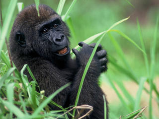
The Eastern Congolian swamp forest, combined with the neighboring Western Congolian swamp forest, contain some of the largest areas of swamp forest on the planet. Although not known to be particularly outstanding in either species richness or endemism, these forests are largely intact. Poaching is likely to have reduced populations of forest elephants (Loxodonta africana cyclotis) along the main rivers, especially close to any navigable waterways. Biologically, this is one of the least known ecoregions in the world, and surveys are urgently needed. Conservation efforts are required to safeguard populations of bonobos (Pan paniscus), and to assist the management of protected
The Eastern Congolian Swamp Forests are found on the left bank (facing downriver) of the Congo River and its tributaries, forming a large arc across the central portion of the Congo Basin. The ecoregion is located wholly within the Democratic Republic of Congo.

Topographically, the area is almost entirely flat and occurs between 350 and 400 meters (m) in elevation. It is a part of the wet tropics, with mean annual rainfall over 2,000 millimeters (mm), and mean maximum temperatures over 30°C. Mean minimum temperatures range between 18 and 21°C. There is little seasonality, as the area is close to the equator, and the humidity level is high. Human population densities average around 12 persons per km2, and are generally concentrated in villages along the major river systems.


This ecoregion encompasses a number of the Congo River's largest tributaries. The most dramatic change in topography and the largest riparian barrier is the Stanley Falls, located near Kisangani. The most important tributaries and other waterbodies are the following (from west to east): Lake Ntomba, Lake Tumba, the Ruki-Momboyo, and Ruki-Busira-Tshuapa-Lomela systems, the Lulonga-Maringa-Lopori system, and the Lomami system.


It is believed that during the past million years this swamp area has been both significantly drier and wetter than present, and that this region could, at some point, have been beneath an enormous lake. There is debate on whether this area remained forested, or if the forest was lost and replaced by savanna-woodland and other more arid forms of vegetation during the height of the Ice Age cold periods. However, it is generally accepted that there was a considerable drying of the climate in the central Congo Basin region, and it seems likely that the forest at some points was restricted to the wetter riparian areas. The soils overlying these sediments are classified predominantly as gleysols, indicating the considerable waterlogging that the area experiences each year. These soils are found over a large area mapped as 'basins and dunes', which may indicate the past extent of considerable climatic desiccation.

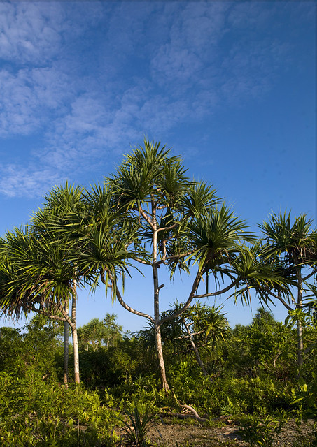
White defined these forests as Guineo-Congolian swamp forest and riparian forest, part of the Guineo-Congolian regional center of endemism. The vegetation consists of a mosaic of open water, swamp forest, seasonally flooded forest, dryland forest, and seasonally inundated savannas, all of which are affected by the seasonal flooding of the Congo River and its major tributaries. The swamp forests are characterized by species such as Guibourtia demeusei, Mitragyna spp., Symphonia globulifera, Entandrophragma palustre, Uapaca heudelotii, Sterculia subviolacea, Alstonia congensis, and species of Manilkara and Garcinia. Permanently flooded swamp regions host areas of near monospecific stands of Raphia palm, which can occupy significant areas within the ecoregion. Levee forests occur on higher ground and host a high diversity of liana species, as well as Gilbertiodendron dewevrei and Daniellia pynaertii growing along the levees. Open areas are home to giant ground orchids (Eulophia porphyroglossa), and riverbanks are often lined with arrowroot (Marantochloa spp).


Biodiversity Features
The flora of the Eastern Congolian swamp forests share elements with both the Western Congolian swamp forests to the northwest and the Central Congolian lowland forests to the south, but contain relatively few endemic plant species. There has been great debate over whether forest persisted in the swamp forests of the Central Congo Basin during the most arid periods of the Ice Age. One line of evidence suggesting that some forest did survive is the presence of a few species, such as the bonobo (Pan paniscus, EN) restricted to the central portion of the Congo Basin. The fact that relatively few narrowly endemic species occur when compared with other Congo Basin ecoregions indicates that the forests may have declined greatly or even been lost.


The Congo River presents a formidable biogeographic and dispersion barrier to many species, with the clearest examples found among the primates. For example, Angolan colobus (Colobus angolensis), Wolf's guenon (Cercopithecus wolfi), bonobo (Pan paniscus, EN), golden-bellied mangabey (Cercocebus galeritus chrysogaster), black mangabey (Lophocebus atterimus aterrimus), southern talapoin (Miopithecus talapoin) and dryad guenon (Cercopithecus dryas) occur only on the left bank of the Congo. In comparison crowned guenon (Cercopithecus pogonias EN), chimpanzee (Pan troglodytes, EN), agile mangabey (Cercocebus agilis), and gray-cheeked mangabey (Lophocebus albigena) occur only on the right bank. The distribution of Demidoff's galago (Galagoides demidoff) subspecies follows a similar pattern, with G. d. anomurus and G. d. murinus found only on the right bank of the Congo and G. d. phasma found only on the left. Allen's swamp monkey (Allenopithecus nigroviridis) is found on both sides of the Congo River.

Near-endemic small mammals include a brush-furred rat species (Lophuromys huttereri), Allen's striped bat (Chalinolobus alboguttatus), and Muton's soft-furred mouse (Praomys mutoni). There is one strictly endemic rodent species (Praomys mutoni). Gaps in knowledge still remain. While a vast body of information exists in museum collections in Belgium, further research, as well as additional floral and faunal surveys, are necessary to determine even the most basic biological information about this ecoregion.

Avifaunal richness is moderately high in this ecoregion, although no birds are known to be endemic. Some biome-restricted bird species present within the ecoregion include Congo black-bellied sunbird (Nectarinia congensis), African river martin (Pseudochelidon eurystomina, DD) and the Congo martin (Riparia congica).

Several amphibians and reptiles are endemic to this ecoregion, although only one amphibian is strictly endemic: the tiny wax frog (Cryptothylax minutus). There are also four near-endemic reptiles: the gray chameleon (Chamaeleo chapini), Gastropholis tropidopholis, Polemon robustus, and Zygaspis dolichomenta.


Current Status
It has been recently estimated that about 124,000 km2 of swamp forests remain in the Congo Basin, with perhaps half in this ecoregion. The Congo River is a highly navigable waterway, making most of the area accessible to poachers. Salonga National Park, Lomako Reserve, and Lomami Lualaba Forest Reserve all fall within this ecoregion, although Salonga N.P. contains the largest area of swamp forest under formal protection. Tumba is another area that has been proposed for protection, as have other priority areas for biodiversity conservation.


Types and Severity of Threats
Logging and associated poaching are the major threats in this ecoregion due to the ease of access through the Congo River and its tributaries. The Service Permanent d'Inventaire d'Amenagement Forestier has noted that extensive areas along the left bank of the Congo River has been allocated as concessions for logging.

Hunting is a major threat. Larger species are hunted for bushmeat, elephants are hunted for ivory and meat, and bonobos are hunted for meat, fetishes and the pet trade. Anecdotal information suggests that elephants have disappeared from large areas. Elephant hunting in the Democratic Republic of Congo is extremely well organized and professional. Areas close to the Congo River and other major waterways may have also suffered reduction in other wildlife populations, including bonobos.


Justification of Ecoregion Delineation
The boundaries of the Eastern Congolian Swamp Forests roughly follow those mapped by White. Although the entire swamp forest is floristically similar (albeit relatively species-poor), it was separated into an eastern and western section based on the significant ecological barrier that the Congo River presents to non-flying vertebrates. This is clearly shown by the primates of this ecoregion; especially by the presence of bonobo (Pan paniscus), which is absent on the right bank of the Congo River

The Seychelles Islands Forest

Source google.com.pk
The Seychelles  Islands Forest
The Seychelles Islands were formed millions of years ago from bits of Gondwanaland that were cast adrift when the Indian continent drifted north toward Asia. The Seychelles are made up of 115 islands that can be divided into 2 types: the 42 granitic islands that make up this ecoregion, and low limestone islands.

The Seychelles Islands are justly famous for their coral reefs and the remote Aldabra Atoll - the largest raised atoll in the world. It supports a huge coral diversity and rare land species like the giant tortoise (Aldabrachelys elephantina), vast seabird colonies and important sea turtle breeding beaches. In recognition of its status it is listed as a natural World Heritage site by UNESCO.

The Mascarene forests include the Réunion Islands, Rodrigues Island and Mauritius that were once home to the now extinct Dodo. The Aldabra Islands are also called the Galapagos of the Indian Ocean with most of its surface being the remains of an ancient coral reef.

All the islands experience a humid tropical climate with monsoon rains from November to April.
Size:
5,400 sq. km (2,000 sq. miles)
Habitat type:
Tropical and Subtropical Moist Broadleaf Forests
Geographic Location:
Islands to the north and east of Madagascar, off the east coast of Africa
In Seychelles, species include legless caecilians (a wormlike amphibian), Seychelles paradise flycatchers, Seychelles magpie-robins (Copsychus sechellarum), Seychelles sheath-tailed bat (Coleura seychellensis), Seychelles kestrel (Falco araea), Seychelles swiflet (Collocalia elaphra), Seychelles wild vanilla orchid, stilt palm, Seychelles pitcher plant, and one of the rarest plants in the world, the jellyfish tree - with a total population of less than 30, it was thought to be extinct until rediscovered in 1970. The forests of the Seychelles are also home to the extraordinary Coco de Mer palm (Lodoicea maldivica), with the world's largest nut - coco-de-mer, or sea coconut that weighs in at about 22.5 kilograms!


Seychelles, one of the world’s very last frontiers, promises adventure and breathtaking natural beauty in pristine surrounds still untouched by man.